أصلˇ فاىل(پروندهٔ اس‌وی‌جی، با ابعاد ۲٬۰۴۵ × ۱٬۷۲۰ پیکسل، اندازهٔ پرونده: ۷٫۸۴ مگابایت)

اي فاىل ویکی‌انبار مئن دره ؤ شاىد باخيˇ پؤرؤژه'نˇ مئنأني کاراىته بۊبۊن. فاىلˇ تؤضيحاتˇ ولگ، اؤرهˇ مئنˇ تؤضيحات اي جير نۊشؤن بدأره.

فيچالسه

گب
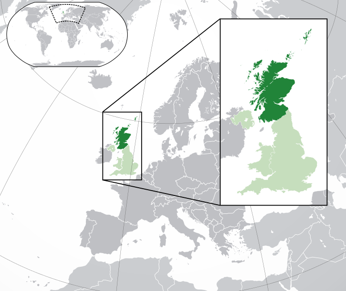
English: A map of Scotland within the United Kingdom and Europe. The map is a polar orthographic projection.
 
Scotland
 
United Kingdom (except Scotland)
 
Europe (except UK)
Español: Un mapa de Escocia en el Reino Unido y Europa. El mapa es una proyección ortogonal polar.
 
Escocia
 
Reino Unido (excepto Escocia)
 
Europa (excepto RU)
Français : Une carte de l'Ecosse au sein du Royaume-Uni et en Europe. La carte est un polair projection orthographique.
 
Écosse
 
Royaume-Unie (sauf l'Écosse)
 
Europe (sauf le Royaume-Unie)
Deutsch: Eine Karte der Schottland drinnen das Vereinigtes Königreich und drinnen Europa. Die Karte ist ein polare orthografische Azimutalprojektion.
 
Schottland
 
Vereinigtes Königreich (außer Schottland)
 
Europa (außer das Vereinigtes Königreich)
Cymraeg:
 
Yr Alban
 
Y Deyrnas Unedig
 
Ewrop
Gàidhlig:
 
Alba
 
An Rìoghachd Aonaichte
 
An Roinn-Eòrpa
Gaeilge:
 
Albain
 
An Ríocht Aontaithe
 
An Eoraip
تاريخ (UTC)
سربس این پرونده مشتق شده‌است از: Blank map of Europe (with disputed regions).svg
چاگۊدنکس

Blank map of Europe (with disputed regions).svg: maix (گب)

دیگر نسخه‌ها
SVG genesis
InfoField
 
کد مبدأ این پروندهٔ گرافیک برداری مقیاس‌پذیر، معتبر.
 
این نقشهٔ جهان با Inkscape ساخته شده است, or with something else.

جواز

w:fa:کرییتیو کامنز
تخصيص انتشار مشابه
این پرونده با اجازه‌نامهٔ کریتیو کامانز Attribution-Share Alike 3.0 سازگار نشده منتشر شده است.
شۊمۊ تؤنين:
  • همرسؤني ئبه – برای کپی، توزیع و انتقال اثر
  • تلفيق گۊدن – برای انطباق اثر
تحت شرایط زیر:
  • تخصيص – شما باید اعتبار مربوطه را به دست آورید، پیوندی به مجوز ارائه دهید و نشان دهید که آیا تغییرات ایجاد شده‌اند یا خیر. شما ممکن است این کار را به هر روش منطقی انجام دهید، اما نه به هر شیوه‌ای که پیشنهاد می‌کند که مجوزدهنده از شما یا استفاده‌تان حمایت کند.
  • انتشار مشابه – اگر این اثر را تلفیق یا تبدیل می‌کنید، یا بر پایه‌ آن اثری دیگر خلق می‌کنید، می‌‌بایست مشارکت‌های خود را تحت مجوز یکسان یا مشابه با ا اصل آن توزیع کنید.

سیاهه بارگذاری اصلی

This image is a derivative work of the following images:

  • File:Blank_map_of_Europe.svg licensed with Cc-by-sa-2.5
    • 2012-02-21T16:27:27Z Alphathon 680x520 (614699 Bytes) Updated Metadata and the boarders/coastlines along the western coast of the Black Sea
    • 2011-09-19T22:57:58Z Alphathon 680x520 (603759 Bytes) Added North/Northern Cyprus
    • 2011-08-23T10:26:48Z Heb 680x520 (604212 Bytes) Added [[:en:Bornholm]] (taken from [[:File:Denmark blank map.svg]])
    • 2011-04-12T00:40:40Z Alphathon 680x520 (602549 Bytes) Upgraded Sicily based on "File:Freeworldmaps-sicily.jpg". Upgraded Malta based on "File:Map of Malta 2.png". Simplified Croatian borders.
    • 2011-04-10T21:43:04Z Alphathon 680x520 (607359 Bytes) Upgraded Croatia, Bosnia & Herzegovina, Slovenia and surrounding countries based on data from "File:Kroatien - Politische Gliederung (Karte).png"
    • 2011-04-10T20:05:09Z Alphathon 680x520 (568373 Bytes) Improved Serbia, Montenegro and surrounding countries using data from "File:Serbia Map.png". Fixed Serbia-Montenegro border. Added Kosovo (using dashed border, since it is not a universally recognised nation, and left the lan
    • 2011-04-10T15:55:02Z Alphathon 680x520 (524980 Bytes) Tweaked Ukraine and surrounding countries based on data from "File:Up-map.png"
    • 2011-04-10T04:02:09Z Alphathon 680x520 (511168 Bytes) Improved Greece, Albania, F.Y.R. Macedonia and Bulgaria based on "File:Greece topo.jpg"
    • 2011-04-10T02:48:52Z Alphathon 680x520 (505569 Bytes) Tweaked Germany and surrounding countries based on info from "File:Germany_general_map.png"
    • 2011-04-10T01:54:05Z Alphathon 680x520 (493733 Bytes) Converted all lakes back to separate layer. Added Finish lakes and tweaked Finland shape based on "File:Finland 1996 CIA map.jpg". Added Swiss lakes based on "File:Suisse cantons.svg". Tweaked Scotland and added Lochs.
    • 2011-04-10T00:07:54Z Alphathon 680x520 (450120 Bytes) Improved England outline and added Isle of Wight based on "File:England Regions - Blank.svg". Improved Denmark based on "File:2 digit postcode danmark.png". Improved Sweden based on "File:Map of Sweden, CIA, 1996.jpg"
    • 2011-04-08T15:53:07Z Alphathon 680x520 (438878 Bytes) Upgraded/fixed various parts of the map. Details: *Some minor fixes to Ireland and added some of the larger lakes based on [[:File:Ireland_trad_counties_named.svg]] *Pretty major fixes to Scotland (mainly the west coast and i
    • 2008-09-17T09:50:25Z F7 680x520 (531491 Bytes)
    • 2008-09-17T09:42:57Z F7 680x520 (2353 Bytes)
    • 2008-05-26T19:04:07Z Collard 680x520 (531491 Bytes) uploading on behalf of [[User:Checkit]], direct complaints to him plox: 'Moved countries out of the "outlines" group, removed "outlines" style class, remove separate style information for Russia'
    • 2008-04-30T01:38:52Z TimothyBourke 680x520 (531767 Bytes) Changed the country code of Serbia to RS per [http://en.wikipedia.org/wiki/Serbian_country_codes] and the file [http://www.iso.org/iso/iso3166_en_code_lists.txt].
    • 2008-02-08T22:44:37Z CarolSpears 680x520 (531767 Bytes) validated
    • 2007-07-10T11:47:59Z MrWeeble 680x520 (533112 Bytes) Updated to include British Crown Dependencies as seperate entities and regroup them as "British Islands", with some simplifications to the XML and CSS
    • 2007-05-14T17:17:34Z Zirland 680x520 (540659 Bytes) serbia and montenegro
    • 2007-03-30T20:40:49Z W!B: 680x520 (538830 Bytes) minor corr: update nl:Ijsselmeer, del fi:lakes (all small), add ru:lake Oneka (all ref maps.google), glued northern irland back to ie ;)
    • 2007-02-05T18:44:32Z Maix 680x520 (538295 Bytes) cropped
    • 2007-02-04T15:07:29Z Maix 680x520 (538310 Bytes) {{Information |Description=A blank Map of Europe in SVG format. Every country has an id which is its ISO-3116-1-ALPHA2 code in lower case for easy coloring. |Source=Image based on [[Image:Europe_countries.svg|]] by [[User:Ti

Uploaded with derivativeFX

عنوان

شرحی یک‌خطی از محتوای این فایل اضافه کنید

آیتم‌هایی که در این پرونده نمایش داده شده‌اند

توصیف‌ها فارسی

۲۵ فئوريه 2012

image/svg+xml

فاىلˇ تاريخ

تاريخ/زمتؤنˇ سر کيليک بکۊنين تا اۊ تاريخ/زمتˇ نۊسخه' بىنين.

تاريخ/زمتکلˇ أنگۊشتيأبعادکارگيرنظر
ألؤنˇ نۊسخه‏۶ آگؤست ۲۰۱۴، ساعت ۱۹:۵۹کلˇ أنگۊشتي عکس، ‏۶ آگؤست ۲۰۱۴، ساعت ۱۹:۵۹ تاريخˇ نۊسخه' جي۲٬۰۴۵ در ۱٬۷۲۰ (۷٫۸۴ مگابایت)Rob984Improved version: More accurate coastline, borders, etc. Added Gradient and Longitude and latitude lines. Zoom insert centred on UK.
‏۲۱ فئوريه ۲۰۱۴، ساعت ۱۴:۵۷کلˇ أنگۊشتي عکس، ‏۲۱ فئوريه ۲۰۱۴، ساعت ۱۴:۵۷ تاريخˇ نۊسخه' جي۶۸۰ در ۵۲۰ (۲٫۴۸ مگابایت)Rob984White background so that the edge of the map is clear. Consistency with other European countries' maps also.
‏۱۹ ژانویه ۲۰۱۳، ساعت ۱۸:۱۴کلˇ أنگۊشتي عکس، ‏۱۹ ژانویه ۲۰۱۳، ساعت ۱۸:۱۴ تاريخˇ نۊسخه' جي۶۸۰ در ۵۲۰ (۲٫۴۶ مگابایت)AlphathonAdded Robinson projection to the top left corner.
‏۲۶ فئوريه ۲۰۱۲، ساعت ۲۳:۳۲کلˇ أنگۊشتي عکس، ‏۲۶ فئوريه ۲۰۱۲، ساعت ۲۳:۳۲ تاريخˇ نۊسخه' جي۶۸۰ در ۵۲۰ (۹۴۱ کیلوبایت)AlphathonFixed mis-scaled "large British Isles box"
‏۲۶ فئوريه ۲۰۱۲، ساعت ۲۳:۲۳کلˇ أنگۊشتي عکس، ‏۲۶ فئوريه ۲۰۱۲، ساعت ۲۳:۲۳ تاريخˇ نۊسخه' جي۶۸۰ در ۵۲۰ (۹۴۰ کیلوبایت)AlphathonFixed small England
‏۲۶ فئوريه ۲۰۱۲، ساعت ۲۳:۲۱کلˇ أنگۊشتي عکس، ‏۲۶ فئوريه ۲۰۱۲، ساعت ۲۳:۲۱ تاريخˇ نۊسخه' جي۶۸۰ در ۵۲۰ (۹۵۹ کیلوبایت)AlphathonMore detailed British Isles
‏۲۶ فئوريه ۲۰۱۲، ساعت ۰۰:۳۵کلˇ أنگۊشتي عکس، ‏۲۶ فئوريه ۲۰۱۲، ساعت ۰۰:۳۵ تاريخˇ نۊسخه' جي۶۸۰ در ۵۲۰ (۷۸۹ کیلوبایت)AlphathonAdded missing parts of Belgium and the Netherlands.
‏۲۵ فئوريه ۲۰۱۲، ساعت ۲۲:۳۷کلˇ أنگۊشتي عکس، ‏۲۵ فئوريه ۲۰۱۲، ساعت ۲۲:۳۷ تاريخˇ نۊسخه' جي۶۸۰ در ۵۲۰ (۸۰۶ کیلوبایت)Alphathon== {{int:filedesc}} == {{Information |Description={{en|A map of Scotland (dark green) within the United Kingdom (dark and light green) and Europe (dark green, light green and darker grey).}} |Source={{Derived from|Blank_map_of_Europe.svg|display=50}} |...

اي ولگ اي تاتاىئه خال بدأ دأنه:

فاىلˇ سراسري کارأىتن

اي ويکئن اي فاىله کارأىته دأنن:

نمایش استفاده‌های سراسری از این پرونده.

گتˇ دىتا