فاىل:Great-neck-ny-map.gif
تفکیکپذیری بالاتری در دسترس نیست.
Great-neck-ny-map.gif (۵۷۵ × ۴۲۵ پیکسل، فاىلˇ واويراز: ۵۷ کیلوبایت، نوع MIME فاىل: image/gif)
فيچالسه
| گب |
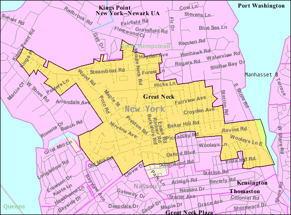
English: U.S. Census 2000 reference map for Great Neck, New York. The amber and light cross-hatched areas bordered in magenta indicate the census tracts included in the census-designated place. The amber-colored areas bordered in black indicate the extent of the incorporated Village of Great Neck. The extent of "Great Neck, New York" as the term is used by the United States Postal Service, local government and local residents includes all the incorporated and unincorporated areas of the entire Great Neck peninsula, as well as an area south of the peninsula extending to the border with Queens (New York City). |
| تاريخ | |
| سربس |
|
| چاگۊدنکس | United States Census Bureau |
جواز
This image or file is a work of a United States Census Bureau employee, taken or made as part of that person's official duties. As a work of the U.S. federal government, the image is in the public domain.
|
 |
سیاهه بارگذاری اصلی
The original description page was here. All following user names refer to en.wikipedia.
Upload date | User | Bytes | Dimensions | Comment
- 2007-11-28 00:59 (UTC) | Americasroof | 58710 (bytes) | 575×425 | [[Great Neck, New York]] map from U.S. Census
فاىلˇ تاريخ
تاريخ/زمتؤنˇ سر کيليک بکۊنين تا اۊ تاريخ/زمتˇ نۊسخه' بىنين.
| تاريخ/زمت | کلˇ أنگۊشتي | أبعاد | کارگير | نظر | |
|---|---|---|---|---|---|
| ألؤنˇ نۊسخه | ۱۰ ژانویه ۲۰۱۲، ساعت ۱۳:۳۳ | | ۵۷۵ در ۴۲۵ (۵۷ کیلوبایت) | SreeBot | (Original text) : Great Neck, New York map from U.S. Census |
فاىله کارأىتن
اي ولگ اي تاتاىئه خال بدأ دأنه:
فاىلˇ سراسري کارأىتن
اي ويکئن اي فاىله کارأىته دأنن:
- ca.wikipedia.org مئن کارأىتن
- cy.wikipedia.org مئن کارأىتن
- en.wikipedia.org مئن کارأىتن
- eu.wikipedia.org مئن کارأىتن
- fa.wikipedia.org مئن کارأىتن
- fr.wikipedia.org مئن کارأىتن
- ht.wikipedia.org مئن کارأىتن
- sh.wikipedia.org مئن کارأىتن
- sr.wikipedia.org مئن کارأىتن
- www.wikidata.org مئن کارأىتن